Our advices
-
See advice
Understanding the GPS
The GPS system is based on a network of 24 satellites which orbit around the world at an altitude of 20 178 km (base orbit.) These satellites emit information on their position and the exact hour (atomic clock)… This information is received by the GPS receiver and permits it to calculateposition. On a GPS receiver everything is automatic, it captures signals from the satellites it surveys and works out its position. In order to do this from a position without altitude, it must receive signals from at least 3 satellites. The more satellites viewed, the more accurate the position. Fixed or portable, regardless of brand or price, all GPS receivers work with the same satellites and display the same position, within a precision of the order of tens of metres for a moving vessel.For improving the accuracy
To improve this precision, ground stations permanently calculate positions and send them toward two geostationary satellites: WAAS (Wide Area Augmentation System,) for -
See advice
Choosing your cartography
Before selecting a card reader, it is necessary to choose its cartography. Each device operates with a unique brand chart. You can explore the characteristics of each of three brands of charts available today in our, “cartography,” dossier. Note that with the exception of Garmin, which has cartography useable only on its own brand’s devices, Navionics and C-Map charts may be read by different brands of readers. There i though, no universal reader. A reader designed to read Navionics charts cannot read C-Map charts and vice versa.Screen size
The quality of a reader is, above all, that of its screen. Larger versions are better, as the surface of the chart is more easily readable. A small screen requires constant zooming, forward and back. Forward to view the route then reversing to plot the boats course on the water. For reading fixed charts, a screen of 7 inches diagonally (18cm,) seems to be the minimum for comfortable reading. When choosing a small screen, -
See advice
Regulations
Since the 1st January 2010, the presence of paper charts on board is no longer obligatory, provided they are replaced by electronic versions. This measure was dictated by the fact that more and more pleasure sailors are travelling with electronic charts. Still, no one is safe from electrical problems on board. All responsible sailors should take paper charts too, in case of emergencies.Raster or vector mapping?
To make electronic charts there is a choice between two methods: scanning paper charts (making a copy: Raster charts,) or the vector. For the vector version, only the significant points of the chart are memorized. It is the software connected with the chart which then connects them with lines (vectors.) So even when zooming the coastline remains the same size (this is not the case with scanning, in which the coastline is magnified by zooming.) The software can also choose to bring up details on the precise level of zoom. For large views it reduces the map. This practice -
See advice
How does it work?
All sounders, graphic or not, function on the same principle. A transmitter/receiver (sensor,) located under the boat sends a sonar signal vertically toward the bottom. When this signal encounters an obstacle, itis returned to the sensor. The sensor’s clock calculates the time taken (transmission/reception) and calculates the depth. This is then displayed, digitally or graphically.Selection criteria
-The number of vertical pixels
Whether monochrome or colour, the screen must be very fine to displaythe details. This is related to the number of vertical pixels taken into account. The horizontal pixels are used only to display the history of the probe as it travels from left to right.
-The sensor frequency
The sensors operate on two frequencies: 50 and 200kHz. A 200kHz probe does not work beyond 200m. Its sweeping cone is large. The 50kHz probe goes deeper but has a narrower cone. We choose the sensor according to the types of fish sought and the depth of the fishing zone. -
See advice
How does radar function?
The signal emitted by the antenna is reflected when it encounters an object and returned to its starting point. This principle may be compared with that of sonar. Radome or apparent, the antenna rotates at about 24 rev/min covering 360°around the boat. To minimize energy consumption, the signal (from 2 to 6 kW, depending on the model,) is sent as short pulses and for optimizing the range as a narrow beam (5 ° in the horizontal plane and 25 ° vertically. ) In normal use the boat is at the centre of the screen, boat’s heading at the top. To measure the bearing and distance of a target relative to the boat, we use the VRM (variable range) and EBL (alidade mobile.) It positions the VRM circle and the EBL on the target (boat, coast, rock…) The VRM indicates precisely the distance of the target from the boat and the EBL the range with an uncertainty of about 5 °.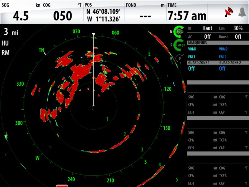
Interpréter une image radar demande de l'expérience.
The range
The range is related primarily to the nature