
Description
The Garmin GPSMAP 1222XSV is a 12'' touch screen GPS handset. Delivered without sensor.
High resolution 12” touch screen. NMEA 0183/2000® compatible for connections with many sensors and instruments such as autopilots, digital switching, FUSION-Link, VHF, AIS, etc. The Garmin Network makes it possible to share sonar data (including Panoptix™), cartographic data, radars, IP cameras as well as user data between several devices. World cartography background: compatible with Garmin Navionics+ and Garmin Navionics Vision+ maps.
Let yourself be tempted by this compact GPS handset with a 7” touch screen. It has wireless connectivity, ANT technology, Garmin Network and NMEA 2000 compatibility to connect to many sensors, probes or applications, and integrates “SailAssist” sailing functions. The GPSMAP 1222XSV also offers Quickdraw Contours and compatibility with Panoptix™ sonar technology.
The GPSMAP 1222XSV is Compatible with Garmin Network and NMEA 2000
Compatible with Garmin Network and NMEA 0183/2000 networks, the GPSMAP 1222XSV can be connected to a wide variety of additional instruments and sensors to take advantage of additional functions directly from the screen of your device. Share sonar data (including Panoptix), chart information, IP video camera images and user data between devices via the Garmin Network. Its compatibility with NMEA 0183/2000 standards allows them to be connected to an autopilot, a VHF, an AIS module, a FUSION-Link audio system and much more.
The GPSMAP 1222XSV has built-in Wi-Fi® connectivity
Enjoy built-in Wi-Fi with BlueChart Mobile 2.0 and Garmin Helm apps. With Garmin Helm, view and control your compatible plotter from a smartphone or tablet running Android or iOS. With BlueChart Mobile 2.0, a free app available from the App Store™, you can get reliable weather information to plan your routes on your iPad® or iPhone®, then transfer it wirelessly to your compatible Garmin chartplotter . You can even control a VIRB action cam and stream video from your camera from your chartplotter screen.
Integrated ANT® connectivity.
Take advantage of built-in ANT wireless connectivity to sync your Quatix® marine GPS watch, Garmin Nautix™ goggle displays, or gWind™ Wireless 2 wind vane with your GPSMAP 1222XSV handset.
The ANT connection also allows you to control your device remotely using the GPSMAP wireless remote control.
The GPSMAP 1222XSV has a built-in sonar module
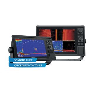
The GPSMAP 1222XSV incorporates a 1kW CHIRP sounder module. It allows you to use any low, medium or high frequency CHIRP probe. The GPSMAP 1222XSV is also compatible with ClearVü CHIRP scanning sonar technology for near-photographic quality display of everything below the boat's hull. Finally, it is compatible with Panoptix technology which allows you to obtain an ultra-detailed and real-time view of what is happening below the surface (sold separately). GPSMAP lets you share sonar data with other devices on the network.
Heading and position refresh ten times per second
Fast and responsive, the built-in 10Hz GPS receiver updates heading data and ten times per second for smoother screen refresh. So you can mark up to 5,000 waypoints with pinpoint accuracy so you can easily return to them later.
Take BlueChart to the next level
Compatible with BlueChart g3 HD and BlueChart g3 Vision HD marine charts, the GPSMAP 1222XSV lets you enjoy highly detailed navigation information and advanced navigation features such as patented Auto Guidance¹ technology that calculates the best course to follow to reach your destination.
Create your own maps with Quickdraw Contours
Quickdraw Contours is a free and user-friendly feature, already installed on your Garmin device. It allows you to instantly create your own HD fishing charts with 30 cm (1 ft) outlines. You can customize them to meet all your needs. After all, these are your cards. You can keep your data to yourself or share it with the Quickdraw community on Garmin Connect™. No topographical expertise is required. You just fish while the software creates your maps. No need to wait or send your files as you would with other mapping software; your results appear instantly. You can use it with any Garmin Panoptix™ or HD-ID™ transducer, any Garmin ClearVü™ transducer equipped with CHIRP technology, or any depth transducer compatible with the NMEA 2000® network. Does your boat have more than one sounder? Quickdraw Contours automatically selects the best performing sonar to give you the best results.
Integrated SailAssist functions
To make the wind your best ally, the GPSMAP 1222XSV incorporates functions specially designed for sailing. This includes a regatta start help page with virtual start line indicator, customizable data fields, laylines to line, a programmable countdown timer that can be synchronized with all Garmin GPS connected to the network. In parallel, the SailAssist functions include the display of laylines, a wind rose with simultaneous display of the true wind and the apparent wind, the display of the heading followed and the heading bottom and much more.
Transfer of GPX waypoints
Have you saved all your waypoints, tracks and routes for years but don't want to lose them? No worries, the GPSMAP 1222XSV allows you to recover all your personal data from your old device even if it was a competing brand device (GPX files).
¹ Autoguiding should be used for planning purposes and does not replace common sea sense.
5000 waypoints, 100 routes, 50,000 points and 50 saved tracks. SmartMode compatible (customization of screen settings). Support for AIS function (search for the position of the nearest vessels). DSC support (displays position data from DSC-capable VHF radios). Tide table. Fusion Link compatible. Compatible with the GCV™ black box sounder. Garmin Helm compatible. Wireless remote compatible. Frequencies: Traditional Sonar (50/77/83/200 kHz), CHIRP (Low, Mid, High), CHIRP ClearVü (260/455/800 kHz).
Maximum depth 1500 m (5,000 ft) at 1 kW (depth capability depends on bottom type and other sea characteristics). User interface: multi-touch screen. Gradual Auto Backlight: Yes Compatible with VIRB® action cam. Compatible with portable devices via ANT network. Compatible with the gWind Wireless 2 probe.
In the box: GPSMAP 1222XSV - Power cable - Mounting bracket - Recessing kit with gasket - Protective cover - Screw covers - Documentation.
High resolution 12” touch screen. NMEA 0183/2000® compatible for connections with many sensors and instruments such as autopilots, digital switching, FUSION-Link, VHF, AIS, etc. The Garmin Network makes it possible to share sonar data (including Panoptix™), cartographic data, radars, IP cameras as well as user data between several devices. World cartography background: compatible with Garmin Navionics+ and Garmin Navionics Vision+ maps.
Let yourself be tempted by this compact GPS handset with a 7” touch screen. It has wireless connectivity, ANT technology, Garmin Network and NMEA 2000 compatibility to connect to many sensors, probes or applications, and integrates “SailAssist” sailing functions. The GPSMAP 1222XSV also offers Quickdraw Contours and compatibility with Panoptix™ sonar technology.
The GPSMAP 1222XSV is Compatible with Garmin Network and NMEA 2000
Compatible with Garmin Network and NMEA 0183/2000 networks, the GPSMAP 1222XSV can be connected to a wide variety of additional instruments and sensors to take advantage of additional functions directly from the screen of your device. Share sonar data (including Panoptix), chart information, IP video camera images and user data between devices via the Garmin Network. Its compatibility with NMEA 0183/2000 standards allows them to be connected to an autopilot, a VHF, an AIS module, a FUSION-Link audio system and much more.
The GPSMAP 1222XSV has built-in Wi-Fi® connectivity
Enjoy built-in Wi-Fi with BlueChart Mobile 2.0 and Garmin Helm apps. With Garmin Helm, view and control your compatible plotter from a smartphone or tablet running Android or iOS. With BlueChart Mobile 2.0, a free app available from the App Store™, you can get reliable weather information to plan your routes on your iPad® or iPhone®, then transfer it wirelessly to your compatible Garmin chartplotter . You can even control a VIRB action cam and stream video from your camera from your chartplotter screen.
Integrated ANT® connectivity.
Take advantage of built-in ANT wireless connectivity to sync your Quatix® marine GPS watch, Garmin Nautix™ goggle displays, or gWind™ Wireless 2 wind vane with your GPSMAP 1222XSV handset.
The ANT connection also allows you to control your device remotely using the GPSMAP wireless remote control.
The GPSMAP 1222XSV has a built-in sonar module
The GPSMAP 1222XSV incorporates a 1kW CHIRP sounder module. It allows you to use any low, medium or high frequency CHIRP probe. The GPSMAP 1222XSV is also compatible with ClearVü CHIRP scanning sonar technology for near-photographic quality display of everything below the boat's hull. Finally, it is compatible with Panoptix technology which allows you to obtain an ultra-detailed and real-time view of what is happening below the surface (sold separately). GPSMAP lets you share sonar data with other devices on the network.
Heading and position refresh ten times per second
Fast and responsive, the built-in 10Hz GPS receiver updates heading data and ten times per second for smoother screen refresh. So you can mark up to 5,000 waypoints with pinpoint accuracy so you can easily return to them later.
Take BlueChart to the next level
Compatible with BlueChart g3 HD and BlueChart g3 Vision HD marine charts, the GPSMAP 1222XSV lets you enjoy highly detailed navigation information and advanced navigation features such as patented Auto Guidance¹ technology that calculates the best course to follow to reach your destination.
Create your own maps with Quickdraw Contours
Quickdraw Contours is a free and user-friendly feature, already installed on your Garmin device. It allows you to instantly create your own HD fishing charts with 30 cm (1 ft) outlines. You can customize them to meet all your needs. After all, these are your cards. You can keep your data to yourself or share it with the Quickdraw community on Garmin Connect™. No topographical expertise is required. You just fish while the software creates your maps. No need to wait or send your files as you would with other mapping software; your results appear instantly. You can use it with any Garmin Panoptix™ or HD-ID™ transducer, any Garmin ClearVü™ transducer equipped with CHIRP technology, or any depth transducer compatible with the NMEA 2000® network. Does your boat have more than one sounder? Quickdraw Contours automatically selects the best performing sonar to give you the best results.
Integrated SailAssist functions
To make the wind your best ally, the GPSMAP 1222XSV incorporates functions specially designed for sailing. This includes a regatta start help page with virtual start line indicator, customizable data fields, laylines to line, a programmable countdown timer that can be synchronized with all Garmin GPS connected to the network. In parallel, the SailAssist functions include the display of laylines, a wind rose with simultaneous display of the true wind and the apparent wind, the display of the heading followed and the heading bottom and much more.
Transfer of GPX waypoints
Have you saved all your waypoints, tracks and routes for years but don't want to lose them? No worries, the GPSMAP 1222XSV allows you to recover all your personal data from your old device even if it was a competing brand device (GPX files).
¹ Autoguiding should be used for planning purposes and does not replace common sea sense.
5000 waypoints, 100 routes, 50,000 points and 50 saved tracks. SmartMode compatible (customization of screen settings). Support for AIS function (search for the position of the nearest vessels). DSC support (displays position data from DSC-capable VHF radios). Tide table. Fusion Link compatible. Compatible with the GCV™ black box sounder. Garmin Helm compatible. Wireless remote compatible. Frequencies: Traditional Sonar (50/77/83/200 kHz), CHIRP (Low, Mid, High), CHIRP ClearVü (260/455/800 kHz).
Maximum depth 1500 m (5,000 ft) at 1 kW (depth capability depends on bottom type and other sea characteristics). User interface: multi-touch screen. Gradual Auto Backlight: Yes Compatible with VIRB® action cam. Compatible with portable devices via ANT network. Compatible with the gWind Wireless 2 probe.
In the box: GPSMAP 1222XSV - Power cable - Mounting bracket - Recessing kit with gasket - Protective cover - Screw covers - Documentation.
Technical characteristics
| Model | GPSMAP 1222xsv |
|---|---|
| Product Brand | Garmin |