Page 3 - Electronics
-
See advice
AIS, what for?
The AIS system, transmits to other vessels, equipped with compatible receivers, information concerning the vessel on which it is installed. Thus is transmitted, the vessel’s identification (MMSI number and name,) its position, course, speed, characteristics (length, width, water displacement,) and possibly information concerning its cargo and destination…All this information is emitted continuously, whether in coastal waters or on the high seas. A vessel which receives an AIS signal can thus visualise the course and speed of the sender and assess the chances of a collision long before it occurs. It is therefore, an invaluable tool for avoiding collisions at sea. This system operates on VHF frequencies (161.95MHz and 162.025MHz.) It is mandatory on all vessels over 300 tons and passenger ships. But many fishing vessels and
even recreational boaters also utilise it. For leisure craft, one may choose to be limited to a single receiver. Thus, "we see, but without being seen." -
See advice
What Navtex?
The Navtex (Navigational Telex) is an official international system developed in the area of GMDSS, for sailing professionals. The receivers have been developed for leisure craft. They are simple to use and once programmed, will receive bulletins and keep them stored in the memory.
Two types of receptors are proposed: autonomous with LCD screen for reading messages and without screen with a PC output, which connects via a USB port to a computer.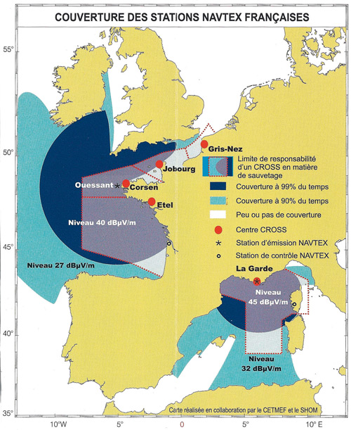
La France possède deux émetteurs (Ouessant au large de Brest et La Garde près de Toulon) qui émettent des messages en français.
Navtex: how does it work?
All transmitters operate on a single frequency, 518 kHz (with a second frequency of 490 kHz to issue national language.) In order to avoid interference between stations in the same area, the diffusion of messages is on specific time slots (every 4 hours) except for BMS. In practice, each service area, called NAVAREA, is divided into geographic area and assigned a letter. For example, -
See advice
Chosen according to navigational needs
In coastal Europe, the weather is broadcast, according to the areas and times, on the long wave (LW 150 to 250 KHz), short wave (MW from 530 to 1620 kHz) and frequency modulation (FM 88 to 105 MHz). To capture these frequency bands, a general public receiver is useful. For long range sailing, it is not enough. An MHF-SSB, receiver is a necessity, sensitive enough for fine tuning. Note that some receivers have an output for receiving the Navtex and weather charts on a computer.The wideband receiver
The CROSS organisation have selected this mode of transmission tobroadcast, on the frequencies 2677KHz and 1696KHz, weather bulletins (with a range of about 250 miles) and for watching, the frequencies 2182 KHz and 2187.5 KHz. Note that outside the range of SSB transmissions, one may receive on short wave (4 to 16MHz, depending on the season,) very detailled bulletins broadcast by Radio France International (RFI.) The transmission frequency is variable (11700 -
See advice
Very useful onboard
Walkie-talkies enable a system of short range communication, one can have a private conversation without being disturbed (as opposed to VHF.) They are useful, for example, when a person is working on the masthead, to keep in contact, or when someone is using the dinghy (over limited range.) It is particularly useful when someone is disembarked to land, from where the use of VHF is prohibited. They are a small investment .Professional advice
“ Walkie-talkies are easily used by the entire crew. Thick of protecting them in a waterproof cover for use in the dinghy.”
-
See advice
Three competing satellite constellations.
Iridium, Inmarsat and Thuraya, behind these three brands lies a satellite network and global coverage. Iridium and Inmarsat have worldwide coverage. They work throughout the world. Thuraya operates a geostationary satellite and a terrestrial station located in the United Arab Emirates. This system covers a large zone in Europe and Africa (North Sea, English Channel, Atlantic and Mediterranean.) It is not therefore, effective, approaching the American continent. From 2011, it will also cover the zone Pacific Asia (Thuraya 3.)