
Description
The Garmin Navionics Vision+™ cartography range has the same characteristics as the Garmin Navionics+™ range with the addition of:
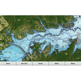
-High-Resolution Terrain Shading¹ combines color and shading to give you a clearer and easier-to-interpret view of bottom structure than just bathymetric curves.
-High-resolution satellite imagery overlaid on navigation charts gives you a realistic view of your surroundings - ideal for entering unfamiliar ports.
-Aerial photography of ports, bridges, docks, shipping landmarks and more, gives you a better idea of what's around you above the waterline.
-Unique 3D views, such as MarinerEye and FishEye, provide additional perspective above and below the waterline.
¹Available in parts of UK, Ireland, Belgium, France, Germany, Netherlands and Norway.