
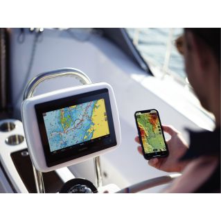
Description
Sail to your paradise with the best and latest Garmin Navionics+™ marine cartography on your compatible Garmin chartplotter. For coastal or inland waters, this all-in-one solution offers detailed, integrated mapping of coastal features, lakes, rivers and more. It features depth zone coloring, advanced Auto Guidance+™ technology and access to daily updates via the ActiveCaptain® app to get the latest map data on every ride. Combining the best features of Garmin and Navionics® autorouting solutions, Auto Guidance+ suggests a path for you to follow through canals, marina entrances and more. Multiple shade options make it easy to navigate shallow waters and easily select depth ranges for the best fishing spots.
Garmin Navionics+™
-Integrated content from Garmin and Navionics®, with an updated color palette and new Navionics-style graphic identity, delivers exceptional coverage, clarity and detail.
-Easy access to daily map updates is available through the ActiveCaptain® app.
-Built-in Auto Guidance+™ technology uses desired depth and clearance, along with map data and frequently traveled routes, to calculate a suggested path from dock to dock.
-Depth Zone Coloring allowing you to select up to 10 color options and view your target depths at a glance.
-To improve fishing and navigation, bathymetric curves down to 30cm provide a more detailed representation of bottom structure.
-For easier navigation, the shoal coloring feature highlights depths down to a user-defined level.
-ActiveCaptain® Community content provides valuable points of interest, recommendations and tips from boaters with first-hand experience of the local environment.
-Global coverage available
-Available on microSD™ cards or via download (each region sold separately), map updates are available by renewable annual subscription (the first year of updates is included).